고정 헤더 영역
상세 컨텐츠
본문

Powerful Typhoon Kanoon, Expected to Make Landfall Tomorrow Morning

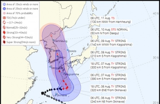
The projected path of Typhoon No. 6, Kanoon, has shifted further westward, increasing the possibility of the typhoon passing through the Korean Peninsula.
According to the Korea Meteorological Administration on the 7th, Typhoon Kanoon is expected to make landfall on the Korean Peninsula on the morning of the 10th, around 90 km southwest of Busan at approximately 9 a.m., with an intensity of 'strong'. By around 3 p.m., it is anticipated to traverse the Korean Peninsula, passing around 60 km northwest of Daegu with an intensity of 'moderate', before moving out towards North Korea on the morning of the 11th.
Consequently, the Korean Peninsula will be under the influence of the typhoon from the 9th.
If the current projected path holds, the entire country will be within the radius of strong winds at about 15 m/s.
Particularly, regions expected to fall within the 'storm radius' (where winds blow at about 25 m/s) as the core of the typhoon passes include the southern coastal areas, inland areas of Gyeongsang and Jeolla, and inland areas of Gangwon and Chungcheong on the 10th.

As Typhoon Kanoon traverses the Korean Peninsula, the eastern coastal regions of Gyeongsang are anticipated to experience momentary gusts reaching up to 40 m/s, which is equivalent to the strength of winds that could derail a train.
The expected momentary maximum wind speeds by region are as follows:
▶ Gangwon Yeongdong, inland areas of Gyeongsang, and Jeju Island at 25-35 m/s (capable of lifting roofs)
▶ Inland areas of Gyeonggi southeast, Gangwon Yeongseo, eastern Chungnam, Chungbuk, and eastern Jeolla at 20-30 m/s (capable of blowing signs or roofs)
▶ Greater Seoul area, western Chungnam, and western Jeolla at 15-25 m/s (capable of blowing signs) and so on.
Heavy rainfall is also predicted.
Until the 8th, Yeongdong in Gangwon is expected to receive 50-150 mm (many places exceeding 200 mm), northern coastal areas of Gyeongsang at 5-60 mm, Ulleungdo and Dokdo at 5-20 mm, and Jeju Island at 5-40 mm.
During the peak impact of the typhoon on the 9th and 10th, Yeongdong in Gangwon may receive 50-150 mm (potentially exceeding 500 mm), Gyeongsang regions 100-200 mm (many places exceeding 300 mm), and other parts of the country 50-100 mm of rainfall.
In the past, a typhoon that traversed the central part of the Korean Peninsula was Typhoon Sanba in 2012.
At that time, flooding and power outages disrupted train services, and fatalities occurred due to landslides.
Although Typhoon Kanoon (central pressure 970 hPa) is less intense than Typhoon Sanba (central pressure 955 hPa), its slower movement speed (15 km/h compared to Sanba's 50 km/h) could potentially cause greater damage.
The path and intensity of Typhoon Kanoon are still subject to change.
The westward shift in the projected path from the previous day is due to the expansion of the North Pacific high-pressure system located to the right of the Korean Peninsula.
Forecasts from various global numerical weather prediction models differ widely, with differences in the projected paths spanning up to 700 km east-west.
In particular, the UK Met Office Unified Model (UM) forecasted that Typhoon Kanoon might move northward entirely over the West Sea.
All right reserved Stay14 Bespoke
'Latest News' 카테고리의 다른 글
| A Night of 'K-Pop Super Live,' united into one 40,000 Jamberry Members (0) | 2023.08.12 |
|---|---|
| Pizza in Korea (0) | 2023.08.10 |
| Why Did Elemental Do So Well in Korea? (0) | 2023.08.07 |
| NewJeans' Performance Draws Largest Crowd at Lollapalooza (0) | 2023.08.06 |
| Infinite Made a Comeback For the First Time in Five Years (0) | 2023.08.04 |


댓글 영역